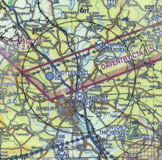
 Well, that's the first circle I've flown in a few years (not counting yesterday) and it could have been worse. Click the little map for a better view. I lost it a bit just before North Newington because I was trying to take a photograph. The real slip was near Balscote where I picked the wrong junction on the Wroxton road. I spotted the mistake at the time but couldn't work out where I'd gone wrong. The next reference point was Radley which brought me back on track. If you've never flown a circle, give it a try. It's harder than you may think. If you have to get the airspeed right and record the position of ground features, which is a typical competition task, it can be a real challenge.
I used the European version of Memory Map Navigator to view the result. I scanned in the map with the circle, calibrated it and then imported the trace from my old Garmin GPS. I set the time interval at 5 seconds. The big errors are mine. The smaller deviations could be me or they could be cartographical differences - the CAA charts aren't as accurate as an Ordnance Survey 1:50,000 map.
 It was a fine day, a few degrees below freezing but plenty of sun, so the circle wasn't as challenging as it could have been. It's the bits of open field with no reference points that are the most difficult. You simply have to interpolate and wait for the next reference point. The CAA 1:25000 chart is really not the best for this sort of thing but it's the one we use.
This is a nice shot of the Dasset Hills, the 689 ft spot height at the northwest of the circle. If you drive up the M40 north of Banbury you can see them clearly on the east of the motorway.
Geoff Weighell flew in in his very smart GT450 shortly after I landed so we took pics of each other for the blog - and here they are.


